The  Navigation System Navigation System
While the QE Too always carries a set of paper NOAA and Canadian Hydrographic charts
for the intended cruising area, most of the navigation is done with an electronic
chart display. There are three parts to this system:
- A notebook computer with a navigation program and raster charts on CD-ROM.
- A GPS reciever
- An autopilot connected to the GPS and the notebook computer
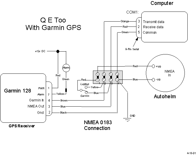
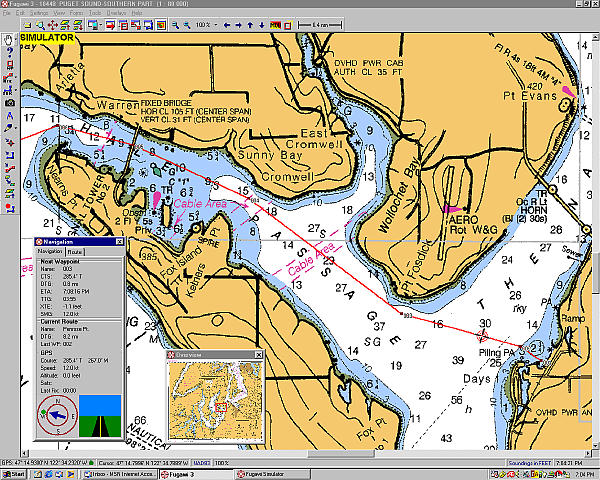
The navigation software is Fugawi 3, from Northport Systems Inc. It displays the charts on a color 15 inch
notebook computer. The GPS is a Garmin 128 with external antenna. The computer is connected to the GPS NMEA
output so that the display shows the position of the Q E Too on the chart. The intended course is entered
into the computer and you just steer to follow the course line on the display.
The display also has a window showing course heading, so you can manually set the autopilot
to follow the course. If there is any cross track error due to wind or current, you see this on
the display and can correct for it by manually jogging the autopilot either left or right,
as necessary. The autopilot is also connected to the GPS NMEA output and can receive guidance
from the GPS. The GPS "GOTO" function will automatically direct the autopilot. In this mode,
called the tracking mode, the autopilot automatically steers to the waypoint, which is useful on
the longer course legs. Courses can also be stored in the Garmin GPS receiver and can direct the
autopilot to the stored course.
In addition, the autopilot NMEA input can also be switched to the Fugawi 3
output and follow a course from the notebook computer.
|
Here is the setup:

Here is a typical display:
|