Return Click here

Troubadour 1989 Smith Sound Exploration

In the fall of 1989, the Troubadour ventured into the (then) uncharted waters of Smith Sound, a tributary of Queen Charlotte Sound between Cape Caution and Rivers Inlet. Here is Dean's account:


SMITH SOUND via CRUISE-A-HOME


By Dean Singer

The island at the end of the channel loomed almost mid-channel ahead of us. A five-knot current pushed us toward its south side. The chart showed the deep water passage to the north, but from our bridge that passage looked only twenty feet wide, and disappeared around the corner of the island. Most of the current was passing to the south, pushing us rapidly that direction. Was this the island we thought it was? Had we misread the chart? Would we 'crash and burn' here? Whose bright idea was it to come to Smith Sound, anyhow?

Smith Sound has been ignored by many otherwise adventurous boaters over the years. Many have cruised northbound to Rivers inlet, Hakai Pass or even Alaska, and hurried quickly past the inlet tucked behind Egg Island on Queen Charlotte Sound, without even looking east. After all, none of us wants to spend any more time than necessary crossing the big water, so we're not inclined to explore a little-known, partially uncharted inlet that's only part way across.

In the summer of 1989, we decided to make Smith Sound our destination to get answers to some questions we've been asking ourselves: What have we been missing? How accurate are the charts? What about the uncharted areas? Aren't there lots of reefs and rocks?

From the south, Alexandra Passage is the most obvious entrance to Smith Sound. We entered from the north via Irving Passage between False Egg Island and Ruby Rocks. In either case, Canadian chart 3776 takes most of the mystery out of negotiating the entrance. There is adequate navigating room in the various passages leading into the sound, and the dangers shown on the chart can be easily seen from your vessel.

On the north side of the sound, you first pass Millbrook Cove, a good hiding place in case of bad weather according to the B.C. Sailing Directions (Coast Pilot). Anchorage can be found behind Millbrook rocks, marked with a red buoy. There are often net floats and/or fishing boats moored here.

The mountains on the north shore get higher and steeper as you continue east, now in Blackney Channel. Pass between Barb Point on the north and Napier Island on the south to enter Boswell Inlet, about twelve miles from the entrance to the sound. A row of pilings along the shore is the only remaining sign of the charted town of Boswell, or its store and fuel facility. No moorage or anchorage is possible here. There is much evidence of logging as you continue eastward, concluding with a prosperous-looking camp and booming

operation on Security Bay. We didn't stop to inquire, but have usually been permitted to tie up to logging camp floats or booms. The protection there would be excellent.

At this point, you reach the eastern limit of the chart. Security Bay itself continues only about a half-mile and is lined with log booms. The main body of Boswell Inlet continues east about five miles off the chart. We proceeded to a narrows about a mile east, beyond which we could see a large bay that appeared to have an island in it. The narrowness of the opening caused concern that it might be more a lagoon than a bay, and we chose not to enter.

Returning west down the south shore of Boswell Inlet, we found Finis Nook, a tiny anchorage due south of the abandoned Boswell townsite. The entrance is narrow; the entire nook is rather shallow and only about a quarter-mile across, but it's well protected from any winds. The eastern half is obstructed by a large rock, and a decaying float and building occupy the shallow southernmost end of the nook.

Our first surprise was that we could no get our anchor to hold when backing down with both engines. Very soft mud and broad-leaf kelp came up with the anchor, and after three


Page 1

attempts, we dropped it astern and tied with a long bowline to a substantial looking dolphin near the old float.

A small seal watched the entire anchoring process. Later, while dinghying around the nook, he (she?) dove off the old float and surfaced six feet behind us. He stared at us for perhaps ten seconds submerged briefly (but totally in view through the clear water) and then resurfaced. Apparently deciding that we were neither interesting nor threatening, he swam a hundred feet away and continued to shadow us during the hour or so we rowed around the area. It was obvious that this was his cove.

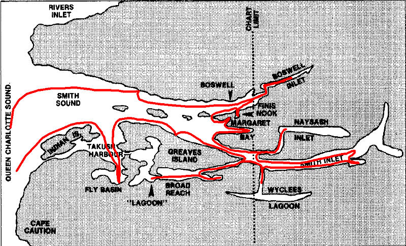
Leaving Finis Nook, if you continue west in Boswell inlet for a mile, swing south around Olive Point and head east again, you'll enter the middle of Smith Sound's three fingers, in which are located Ethel Cove and Margaret Bay. This area is shown in detail on chart 3797. (Finis Nook also shows better detail on the Margaret Bay chart.)

Ethel Cove has depths suitable for anchoring, but appears open to a prevailing westerly swell. Margaret Bay, a few hundred yards south, is a mile long and is protected from the swell by Chamber Island about half way in. Only a wharf in ruins remained at the location of an abandoned store, oil tanks and post office. During our visit, a deer browsed in a flat area we

presumed to be the townsite. The bay is quite narrow and shallows quickly near the wharf, but adept anchoring and/or stern-tying techniques would provide a great base camp for exploring the townsite and the mudflats to the east. If that area were judged too tight, the east side of Chambers Island also offers protection, but would still require stern tying.

When leaving Margaret Bay, favor its north shore to avoid Camosun Rock. Rounding Ripon Point puts you in Smith Inlet, the southernmost finger. About six miles into the inlet, uncharted Naysash Inlet branches northeast. We ventured about a mile east to Hickey Cove, where the inlet turns north. This pretty place offers secure anchorage. North of here about a mile and a half, the inlet turns east again for a reported six more miles, but it narrows and shallows quickly, making it unsuitable for exploring except by dinghy.

Reentering Smith Inlet, it is possible to cruise east (off the chart) several miles further; the inlet continues about 12 miles. We traversed half of it and saw no obvious dangers. On the south shore, still in the uncharted portion of Smith Inlet, Wyclees Lagoon branches south three miles, then tees east and west for about six miles each direction. The lagoon is not shown on chart 3776, but is shown in white (unsurveyed) at the top of chart 3552-Seymour Inlet and Belize Inlet. Again,

the narrowness and assumed shallowness of the entrance overwhelmed our desire to explore the lagoon, and we did not enter.

Back on the chart, due south of Naysash Inlet, is Ahclakerho Channel, which runs southwest for five miles between Greaves Island on the north and the mainland on the south, leading to Broad Reach. The Coast Pilot describes it as tortuous. The large volume of water in Broad Reach in relation to the narrowness of Ahclakerho Channel makes for strong tidal currents in the channel. The entrance to Broad Reach at the southwest end of the channel is not as straightforward as the chart indicates. It is here that the events noted in the opening paragraph occurred.

We felt confident that we had observed the channel carefully, and knew where we were. But this was one of those times when things look differently from the helm of your boat than they did on a chart while seated in your favorite chair. Thus we found ourselves being propelled toward the wrong end of the island, while the channel at the right end looked like nothing more than a bight.

Saying a silent prayer to the guys who make Canadian charts, I pushed the throttles forward and cranked the wheel to the right. We crabbed in the current, the bow pointing toward the fallen snags jutting out from the north shoreline. As we passed the eastern


Page 2

tip of the island, the current diminished, and the opening began to look more like a true passage. It was the deep channel we wanted. Looking south as we passed the other end of the island, we could see ripples and even a few rocks protruding on that side of the island. We had obviously chosen correctly. We enjoyed the exhilaration of a tricky passage well navigated.

Broad Reach runs about two miles east and six miles west from the point where Ahclakerho Channel enters. The hillsides are not so steep as they were further east. Much of the shoreline bears evidence of hand loggers, and while this detracts from the overall beauty, there are numerous coves, bays, and channels to satisfy the exploring instincts of most boaters.

To visit the east end of the reach, pass between the two Ahclakerho Islands, or west of both of them. Several nooks indent the shore, many with depths shallow enough for reasonable anchoring. All have exposure to wind however, and wind seemed to be an every afternoon event.

The west end of the reach is divided by a peninsula, north of which is a rather large open bay which we rejected as being too exposed, and

south of which is a channel leading to a shallow body of water which might better be called a lagoon. On the south side of the exposed bay, behind a large rock that dries at 17 feet, we found a bight about 50 feet wide and 70 feet long cutting into the peninsula. Two stern lines were needed to keep us from swinging too far from side to side, but we were well protected from the east wind which was beginning to whip into the main part of the bay.

For the next three days we explored this charming lagoon, which runs northeast nearly two miles. The entrance was encumbered with shore to shore kelp; the depth is shown as three feet at chart datum. It seemed there was usually a 4 to 5 knot current there, with virtually no slack water. We concluded that attempting to enter or anchor here with a "big" boat would be foolhardy in most conditions. Inside the lagoon, most depths are less than ten feet, and much of it goes dry at mid-tide. We spent a good deal of time going aground-often a half mile from shore-in a dinghy that draws less than a foot of water.

The shallow depths and clear water made it easy to spot a large number a fish, crabs, mussels, a four-foot skate and (we thought) an octopus. The drying flats were dotted with grounded

and sunken drift logs. Minks frolicked along shorelines obliterated in many places by jumbles of fallen snags. Entire bays were dry at mid-tide, and only inches deep a higher water. Tiny channels branched off, usually to nowhere. Our favorite, perhaps a half-mile long, less than ten feet wide, and drying at seven feet, passed west to Takush Harbour. This tiny two-way creek is the separation between Greaves Island and the mainland.

Attempting to negotiate this passage, we found a tidal pool formed between rocks constricting the lagoon end and a shoal a few hundred feet west. Brilliant green anemones, chitons, tiny crabs and snails covered the rocks, while the bottom was carpeted with broken clam shells. We were able to pass south of the shoal on a nine-foot tide, but lacked about a foot of depth and width to clear the last couple of rocks on the east end at that tide level. We were close enough to see into Takush Harbour from that point, and vowed to try it from the other side later.

To get to that other side with a big boat involves a 28-mile trek reversing your course out of Broad Reach, back through Ahclakerho Channel, and around Greaves Island. Our passage was made in light fog and light to


Page 3

heavy showers. We skipped McBride Bay, fearing that we might not be able to spot the one and two-fathom shallow areas in the poor visibility.

Takush Harbour itself is rather large and open for a harbor as we usually think of them, and it's full of rocks. A lot of care needs to be taken when navigating here. We never found a charted six-foot drying rock down in the middle of the main entrance, although Fish Rocks near by were apparent. We stayed close to a charted private beacon near Petrel Shoal to avoid the unseen six-foot rock. A wreck is right where the chart shows it, and uncovers at about two feet.

Because of the openness of Takush, we chose to go through it and into Fly Basin. It's necessary to favor the west side of the channel; a nine-foot drying rock in the channel is further north than shown, and nearly mid-channel. Once inside the basin, we found the west end shallower and more narrow than the chart looked. Traversing to the east end, we found that the 'dries two feet' rock shown off the north shore opposite Fly Point has a twin a hundred feet further from shore, which dries at zero feet. Make sure which one you see!

There is adequate anchoring space and depth in the east end of Fly Basin. However, the soft bottom conditions

noted earlier prevail here just as they had at all our other anchorages in Smith Sound.

The hillsides around Takush Harbour and Fly Basin are not as high as those around Broad Reach. That, plus being closer to Queen Charlotte Sound makes it easier for winds to reach into them. A slight swell can be felt in Takush, and winds get there through a passage from Browning Channel. No swell was felt in Fly Basin, but it's open to northwest winds from Takush or from the west over a low spot in the hills where a creek leads to Leroy Lake.

Once again, our dinghy was the vehicle of choice to explore these areas. Fly Basin is only a bit deeper than Broad Reach's lagoon, and the shorelines are similar. Takush Harbour is much larger, and offers a number of points of interest. Two days were spent investigating its rock strewn shorelines.

We inspected the wreck along the south shore of Takush Harbour at a zero tide. It appeared to be a steel vessel over 150 feet in length, laying on its side. A part of the superstructure emerged a couple of feet from the water. About twenty feet west, the side of the hull showed, broken jaggedly and separated by a couple of feet. It sloped down both directions from the break.

Prowling area libraries later, and questioning local divers, we found that the wreck was the Drumrock, a log barge that came into Takush Harbour in 1927 to escape a storm, but anchored over a rock and was broken in two when the tide went out. Drumrock Island, just west of Cypress Point is named for the unfortunate craft.

Anchor Bight, on the west end of Takush Harbour, is a better anchorage than it looks on the chart, but a number of rocks must be avoided when entering. A small channel drying at four feet leads west from here to Browning Channel, separating Indian Island from the mainland. We tried to make it with the dinghy, but were grounded before we could get more than a couple hundred feet. A number of rocks and fallen trees were in the channel ahead, so we declared it unnavigable.

On the north shore of Anchor Bight, a sometimes inhabited Indian village is located on Indian Island. Signs there request no trespassing. The Gnarled Islets and rocks making up Petrel Shoal offer spectacular sightseeing, but little beachcombing.

The easternmost bay in Takush Harbour is Broad Bay. Leading eastward from there is the channel leading to the Broad Reach lagoon, which we had attempted


Page 4

earlier. The tide was a couple of feet higher than the first try, so we decided it was time for a second attempt.

A tidal flow against us made it easier to control our progress into the channel. Two overfalls marked the rocks we had been unable to pass from the other side. With little control or depth to spare, we skimmed past both and into the eastern half of the channel. The sandy shoal was now covered by a few inches of water; we skirted it and went a short distance into the Broad Reach lagoon. We again experienced the thrill of having exercised some fancy seamanship, albeit only in a dinghy. Another thrill was the ride out with the tide behind us; the narrow sides, the big rocks and the rushing water made it like a Disneyland adventure ride.

Exiting Fly Basin to Browning Channel requires the same careful navigation as when entering. Westbound in Browning Channel, the more adventurous captain might want to tour Leroy Bay, and go inside of the Search Islets, Chest Island and the Turner Islets. At this point, you are is Alexandra Passage, and it's 36 miles to Port Hardy to the south, or 35 miles to Namu to the north. You have conquered Smith Sound!

In summary, Smith Sound can be an interesting and challenging destination for an adventurous skipper and crew, especially those who like solitude. The shorelines in the larger bodies of water can become boring because of the sameness of the tree and rock-covered terrain dropping steeply to the water's edge, with no meadows or

sloping beaches for wildlife viewing. The coves, inlets and lagoons are quite interesting, but the many rocks and shoals in and around them require cautious navigating. Superior anchoring tackle and techniques are a necessity. Radio reception is poor, except for radiotelephone. A new tower at Coast Cone provides a good coverage.

Would we return there? Probably. The charm of the Broad Reach Lagoon is enough to warrant a return trip. And if the Canadian Hydrographic Service chooses to chart the missing parts of Naysash Inlet and Wyclees Lagoon, you can bet that we'll be back. Maybe not for everyone, but that's our type of cruising.


Page 5

The Troubadour Anchored in Broad Reach, Smith Sound

Return Click here